Australia is an exotic land with unique animals and plants, and a rather quiet
recent tectonic history. It has the lowest average elevation of any continent at about 1,000 feet. To say that the trip is something completely different for me would not truly convey the sense of discovery I have experienced thus far. So it was with great anticipation that that our next stop was to Ozzie's Red Center - the heart of this island continent. It was a dot on the map that our aircraft successfully darted.
Leaving "green" Australia and the city of Cairns. View is to the north along Australia's Pacific shore, known also as the Coral Sea.
Two hours later a much different scene was laid out below Row 17, Seat F - Australia's Red Center and the town of Alice Springs, barely visible the distance where the green ribbon of the Todd River funnels into the gap of the rocky ridge. A series of upturned ridges form the
Macdonnell Ranges in the center of the Australian continent.
A closer view shows an obvious water gap (cut by the Todd River flowing from top right to bottom left) and the heart of "Alice" as it is often called here in the Northern Territory. Rocks within this ridge were upturned in the Alice Springs Orogeny, a 400 to 350 million year warping event that folded strata much like the Valley and Ridge province was folded in North America's Allegheny Orogeny. The water gap is called Heavitree Gap and gives the name to the quartzite, the
Heavitree Quartzite, a Proterozoic deposit between 1,000 and 820 Ma, making it similar in age to the Grand Canyon Supergroup.
A view from the ground in Alice of the Heavitree Quartzite and the ridge in the previous photograph.
ANZAC Hill in Alice Aprings commemorating the many wars that Australia has been involved in
View to the south from ANZAC Hill with the Heavitree Gap in the far distance
Close-up view of the Todd River riparian zone and the Heavitree Gap.
The official flower of the Northern Territory,
Sturt's desert rose (Gossypium sturtianum)
The Northern Territory is the least populated of Australia's six states and two territories. The distances are vast and remote and so, in 1929 the Flying Doctor Service was initiated to help those living out on remote cattle stations. It was a few years later given the appellation Royal. The museum here was fascinating telling the history and growth of the service, now with 63 airplanes in service.
Another innovation necessitated by remoteness is the School of the Air, started in 1951. Many kids in the Outback receive their schooling over the airwaves with teachers talking with far-flung public over the radio.
A type of wallaby (kangaroo) called a Euro
This is where Alice was begun with the completion of the telegraph line from Darwin in the north to Adelaide in the south. An outcropping of granite in the Todd River causes groundwater to surface behind the old station shown here.
We enjoyed a nighttime barb-b-que and handling some of the strange reptile life to be found here in the Simpson Desert.
This animal is related to our horned lizard and is called a bearded dragon (genus Pogona)

The next day we headed out to explore the western Macdonnell Ranges and drove through Honeymoon Gap.
The eucalyptus trees that grow in these river bottoms are impressive specimens
Next stop was at an Aboriginal reserve called Standley Chasm
These mountain recesses form a fire shadow that acts as refugia for ancient plants, now extirpated by bush fires from the open lands surrounding the Macdonnell Ranges. Shown here are
cycads.
Relatives of these plants are reported from Jurassic fossils!
The chasm narrows about one kilometer from the car park
With the current El Niño in effect in the eastern Pacific,
Australia can expect drought to occur this summer. But when it does rain in this part of the continent, the floods are extreme and these gorges have recorded stupendous floods in historical and geologic times.
Ghost gum tree in Standley Chasm
On the road in the Outback with the Macdonnell Ranges looming ahead
Last stop of the day was at Simpsons Gap, another water gap cut into an upturned ridge
On the trail into the gap
Here is the waterhole at the end of the trail. These watering holes are obviously very important to wildlife and people in this part of the world.
Spectacular gum tree in Simpsons Gap
I was happy to have a full day exploring this area west of Alice. Next - on to Ayers Rock!


 The eucalyptus trees that grow in these river bottoms are impressive specimens
 Next stop was at an Aboriginal reserve called Standley Chasm
 These mountain recesses form a fire shadow that acts as refugia for ancient plants, now extirpated by bush fires from the open lands surrounding the Macdonnell Ranges. Shown here are cycads.
 Relatives of these plants are reported from Jurassic fossils!
 The chasm narrows about one kilometer from the car park
 With the current El Niño in effect in the eastern Pacific, Australia can expect drought to occur this summer. But when it does rain in this part of the continent, the floods are extreme and these gorges have recorded stupendous floods in historical and geologic times.
 Ghost gum tree in Standley Chasm
 On the road in the Outback with the Macdonnell Ranges looming ahead
 Last stop of the day was at Simpsons Gap, another water gap cut into an upturned ridge
 On the trail into the gap
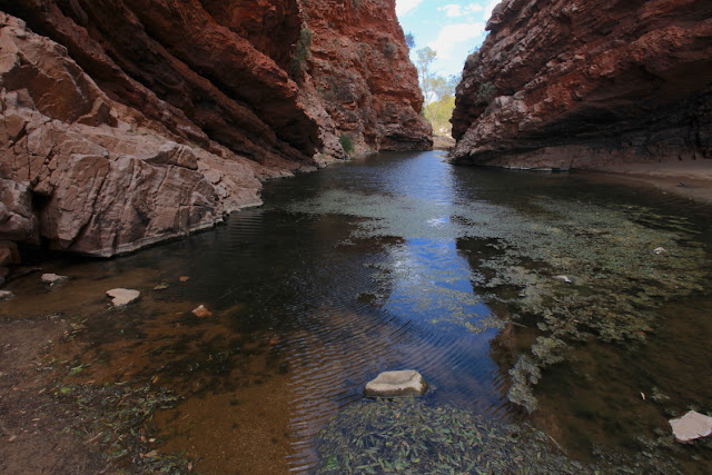 Here is the waterhole at the end of the trail. These watering holes are obviously very important to wildlife and people in this part of the world.
 Spectacular gum tree in Simpsons Gap
 I was happy to have a full day exploring this area west of Alice. Next - on to Ayers Rock!


No comments:
Post a Comment
If your comment will not post, email me with the problem.